
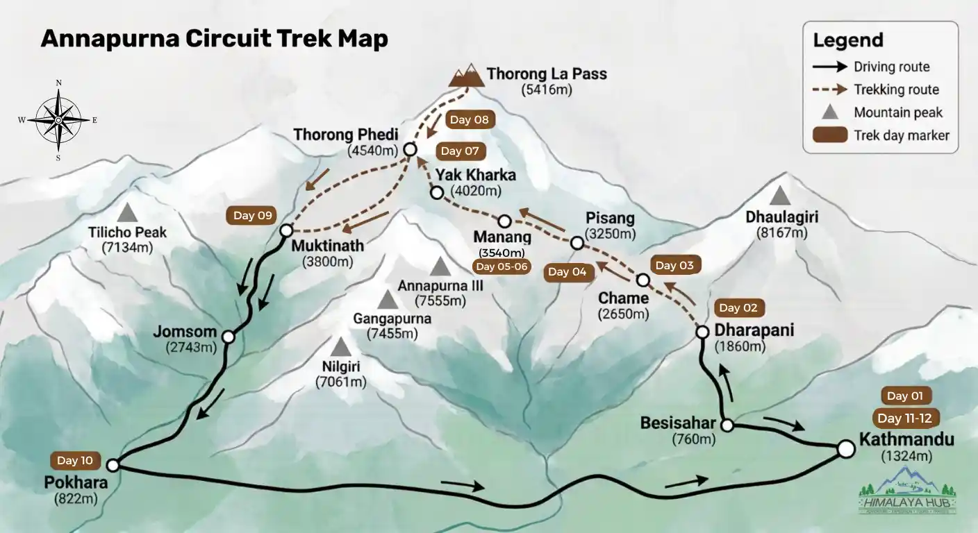

Planning your Himalayan adventure starts with one essential tool: a reliable Annapurna Circuit Trek map. Spanning 160 to 230 kilometers, this legendary route loops around the Annapurna Massif, transitioning from lush subtropical valleys to the high-altitude desert of the Thorong La Pass (5,416m). Whether you are navigating the newly marked NATT footpaths to avoid dusty jeep roads or tracking your daily elevation gain toward Muktinath, understanding your route is crucial for a safe and successful journey.
At Himalaya Hub, we’ve designed this comprehensive guide around our signature 12-day itinerary map. Below, you will find a detailed day-by-day route breakdown, essential navigation tips, updated permit requirements, and expert insights on trail difficulty. Whether you are downloading offline GPS tracks or studying a physical trekking map, this guide provides the exact clarity you need to confidently navigate one of Nepal’s most iconic teahouse treks.
Annapurna Circuit Trek Overview
Your Annapurna Circuit adventure with Himalaya Hub begins in Kathmandu (1,324m), where you’ll arrive, prepare your gear, and meet your certified local guide. From Kathmandu, the journey continues by drive via Besisahar to Dharapani (1,860m) – the official starting point of the main trekking section.
The first few days follow a scenic lower trail through Bagarchhap, Chame, and Pisang, a beautiful mix of pine forests, traditional villages, flowing rivers, and stunning mountain views. From Pisang, the trail continues toward Manang (3,540m), with the option to take the more scenic upper route through Ghyaru and Ngawal for panoramic views of the Annapurna range.
In Manang, Himalaya Hub’s itinerary includes an extra acclimatization day with a short hike to Gangapurna Lake or Praken Gompa. Our guides always prioritize proper altitude adjustment and your safety before the high-altitude section begins.
The trail then climbs to Yak Kharka (4,020m) and on to Thorong Phedi (4,540m) or High Camp (4,880m). The most demanding yet rewarding day is crossing Thorong La Pass (5,416m) – the highest point of the trek, before descending to the sacred town of Muktinath, an important pilgrimage site for both Hindus and Buddhists. Your experienced Himalaya Hub guide stays by your side at every step, ensuring a safe and comfortable crossing.
From Muktinath, you’ll travel by road to Pokhara (822m) – with an optional flight from Jomsom depending on conditions, before driving back to Kathmandu for a farewell dinner with the team. This 12-day itinerary ends with your departure or an optional extension trip, leaving you with memories of a lifetime.
Ready to walk the Annapurna Circuit with a government-licensed, TAAN-registered local operator? Explore Himalaya Hub’s 12-day Annapurna Circuit Trek and start planning your Himalayan adventure today.
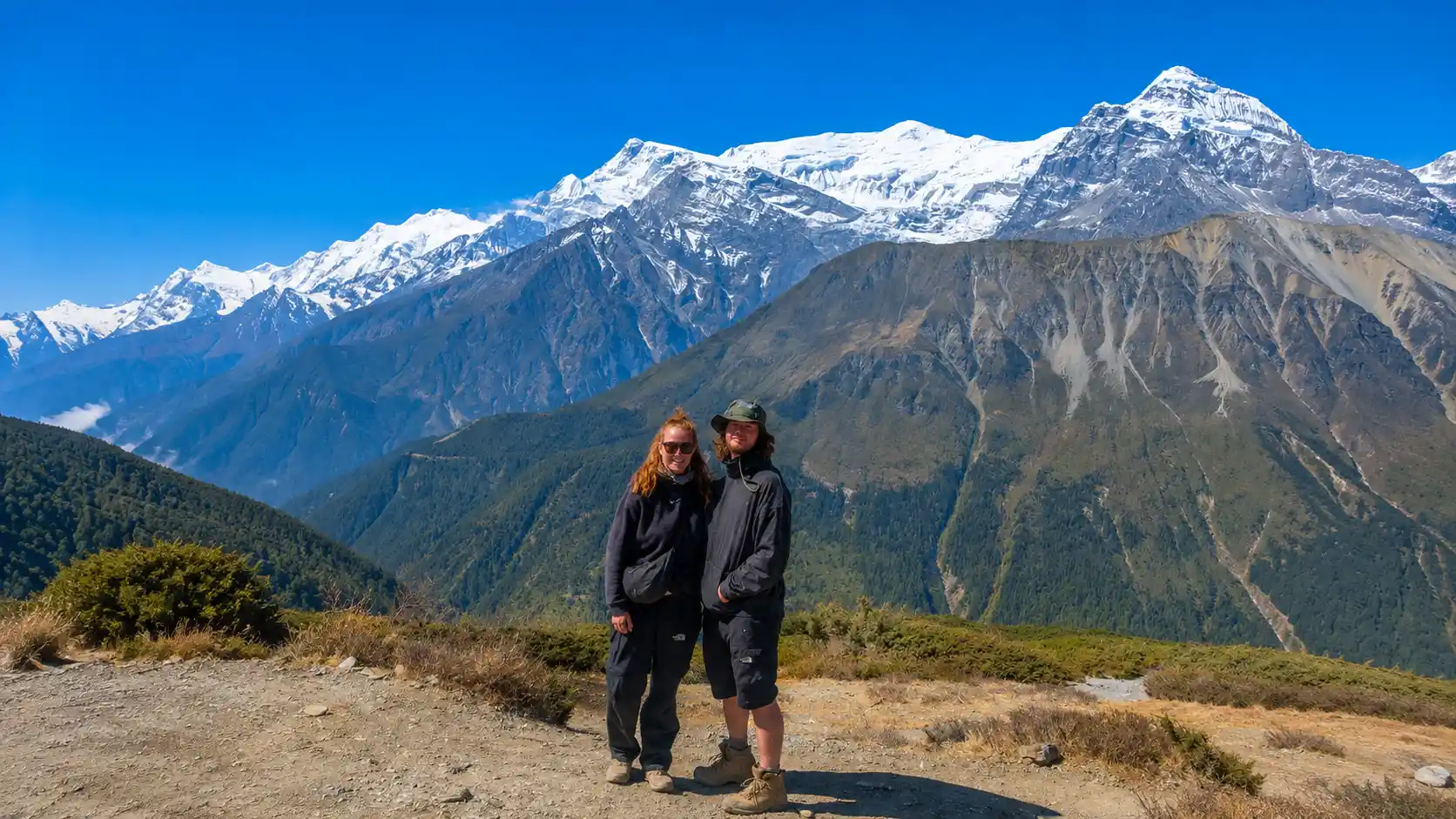
Annapurna Circuit Trek Map – Itinerary Route
Follow our standard 12-day Annapurna Circuit Trek itinerary, a carefully paced route that balances scenic trekking days with proper acclimatization, taking you from lush river valleys to the highest pass of the trek.
Day 01: Arrival in Kathmandu (1,324m / 4,344 ft)
- Activities: Upon arrival at Tribhuvan International Airport (TIA), our team will greet you with a ‘Himalaya Hub’ sign and transfer you to your hotel. After resting, meet your trek leader in the evening for a route briefing, gear check, and a welcome dinner.
- Highlights: Airport transfer, exploring the bustling Thamel market, and final trek preparation.
- Accommodation: Hotel | Meals: Welcome Dinner
Day 02: Drive to Dharapani via Besisahar (1,860m / 6,102 ft)
- Distance & Duration: 240 km | 9 hours drive
- Activities: Start early for a scenic drive along the Trishuli River to Besisahar. From there, continue on a rough mountain road to Dharapani.
- Highlights: Lush green hills, terraced rice fields, local villages, and reaching Besisahar, the official gateway of the Annapurna Circuit.
- Accommodation: Teahouse | Meals: Breakfast, Lunch & Dinner
Day 03: Trek to Chame (2,650m / 8,694 ft)
- Distance & Duration: 15.5 km | 6 hours trek
- Activities: Begin your trek through thick pine and oak forests. Cross suspension bridges and pass through the traditional villages of Bagarchhap and Danakyu.
- Highlights: The roaring Marsyangdi River, Buddhist prayer wheels, and your first clear views of Annapurna II and Paungda Danda.
- Accommodation: Teahouse | Meals: Breakfast, Lunch & Dinner
Day 04: Trek to Upper Pisang (3,250m / 10,663 ft)
- Distance & Duration: 14 km | 6 hours trek
- Activities: Walk through a narrow valley beneath high cliffs, cross wooden bridges, and pass apple orchards. We climb to Upper Pisang for better acclimatization and views.
- Highlights: Entering the rain-shadow zone with drier landscapes and stunning sunset views of Annapurna II.
- Accommodation: Teahouse | Meals: Breakfast, Lunch & Dinner
Day 05: Trek to Manang (3,540m / 11,614 ft)
- Distance & Duration: 16 km | 6 hours trek
- Activities: Choose between the easier lower route via Hongde or the challenging upper route via Ghyaru and Ngawal. Explore Manang village upon arrival.
- Highlights: High-desert landscapes, ancient monasteries, and panoramic views of the Annapurna range.
- Accommodation: Teahouse | Meals: Breakfast, Lunch & Dinner
Day 06: Acclimatization Day in Manang (3,540m / 11,614 ft)
- Distance & Duration: hike
- Activities: Hike to Gangapurna Lake, Praken Gompa, or Ice Lake following the “climb high, sleep low” rule. Attend the free altitude sickness talk at the HRA clinic.
- Highlights: Essential acclimatization hike, stunning photo stops, and learning about high-altitude health.
- Accommodation: Teahouse | Meals: Breakfast, Lunch & Dinner
Day 07: Trek to Yak Kharka (4,020m / 13,189 ft)
- Distance & Duration: 11 km | 5 hours trek
- Activities: A steady, gradual trek through open valleys with sparse vegetation, passing the small settlements of Tenki and Gunsang.
- Highlights: High-desert scenery, yaks grazing in pastures, and experiencing the noticeably thinner air.
- Accommodation: Teahouse | Meals: Breakfast, Lunch & Dinner
Day 08: Trek to Thorong Phedi / High Camp (4,540m / 14,895 ft or 4,880m / 16,010 ft)
- Distance & Duration: 7 km | 4 hours trek
- Activities: A short but steep climb to Thorong Phedi, with the option to push further to High Camp. Enjoy an early dinner and prepare for tomorrow’s big day.
- Highlights: Rocky trails, reaching the base of Thorong La Pass, and final preparations for the highest point of the trek.
- Accommodation: Teahouse | Meals: Breakfast, Lunch & Dinner
Day 09: Cross Thorong La Pass (5,416m / 17,769 ft) to Muktinath (3,800m / 12,467 ft)
- Distance & Duration: 16 km | 9 hours trek
- Activities: Start early (3–4 AM) to cross the trek’s highest point, followed by a steep 3–4 hour descent to the sacred site of Muktinath.
- Highlights: Breathtaking 360° mountain views from Thorong La Pass and visiting the holy Muktinath Temple with its 108 water spouts and eternal flame.
- Accommodation: Teahouse | Meals: Breakfast, Lunch & Dinner
Day 10: Drive Muktinath to Pokhara (822m / 2,697 ft)
- Distance & Duration: 166 km | 10 hours drive (or optional 20-min flight from Jomsom)
- Activities: A short drive to Jomsom through the Kali Gandaki Valley, followed by a long scenic drive (or quick flight) to the beautiful lakeside city of Pokhara.
- Highlights: Traveling through the world’s deepest gorge, relaxing in a comfortable hotel, and celebrating your successful trek.
- Accommodation: Hotel | Meals: Breakfast & Lunch
Day 11: Drive Pokhara to Kathmandu (1,324m / 4,344 ft)
- Distance & Duration: 200 km | 8 hours drive
- Activities: Enjoy a scenic drive back to Kathmandu along the Trishuli River highway. In the evening, join a farewell dinner hosted by Himalaya Hub.
- Highlights: Beautiful Nepali countryside views, sharing trek memories, and a traditional farewell dinner with cultural dance performances.
- Accommodation: Hotel | Meals: Breakfast & Farewell Dinner
Day 12: Final Departure from Kathmandu (1,324m / 4,344 ft)
- Activities: Transfer to Tribhuvan International Airport 3 hours before your flight, or begin an optional extension trip (like a Chitwan Safari or Everest Mountain Flight).
- Highlights: The end of your unforgettable Annapurna Circuit adventure and a safe journey home.
- Meals: Breakfast
This 12-day route is our most popular standard package. Himalaya Hub also offers flexible 21-day itineraries, as well as customized 8-day and 10-day Annapurna Circuit trips and fully personalized private journeys. Contact us to find the perfect route for you.
Read Our : Annapurna Circuit Trek 21 Days Map
Annapurna Circuit Trek Altitude
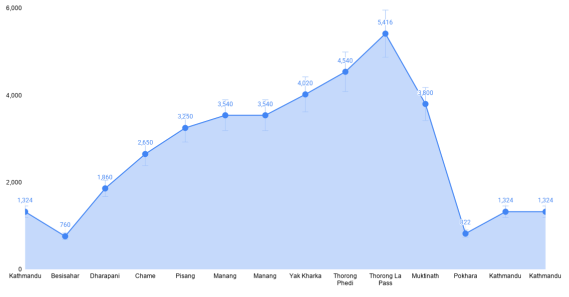
The Annapurna Circuit Trek altitude ranges from about 760 m to 5,416 m (17,769 ft) at Thorong La Pass, the highest point of the trek. The gradual altitude gain gives trekkers time to adjust before reaching the high pass.
- Dharapani: 1,860 m
- Chame: 2,650 m
- Pisang: 3,250 m
- Manang: 3,540 m
- Yak Kharka: 4,020 m
- Thorong Phedi: 4,540 m
- Thorong La Pass: 5,416 m
- Muktinath: 3,800 m
Manang (3,540 m) is the main acclimatization stop before climbing higher. Walk slowly, stay hydrated, and follow your guide’s advice as the altitude increases. After crossing Thorong La Pass, the trail descends toward Muktinath and lower Mustang.
Understanding the Annapurna Circuit altitude profile helps you prepare for the changing conditions and plan a safer, more comfortable trek.
Accommodation During Trek
Your standard trekking package follows the classic Annapurna Circuit route, offering a comfortable mix of authentic mountain teahouses and premium city hotels. In your 12-day itinerary, you will spend 9 nights in local teahouses along the trail, while enjoying luxurious star-rated hotel stays in Kathmandu and Pokhara to properly relax before and after your mountain adventure.
While the teahouses on the trail do not offer star-hotel luxury, they are exceptionally well-developed compared to other remote Himalayan regions due to the Annapurna Circuit’s immense popularity. You will receive a welcoming, moderate level of service throughout your journey. Additionally, if you prefer a more premium experience on the mountain, you can easily upgrade to our luxury package for enhanced comfort and better facilities.
During your teahouse stays, you will rest in warm, cozy rooms typically featuring twin or adjacent beds. To ensure a comfortable night’s sleep after a long day of trekking, the rooms are fully equipped with essential amenities, including comfortable mattresses, thick blankets, pillows, and clean towels.
Bathroom facilities vary depending on your altitude. In the lower villages, you will find modern Western-style bathrooms with standard shower facilities. However, as you ascend to higher elevations, traditional-style bathrooms become the norm. At these higher camps, purchasing a bucket of hot water is the best and most reliable alternative for a warm shower.
How Difficult is the Annapurna Circuit Trek?
The Annapurna Circuit is generally rated as moderate to strenuous. While it is not a technical climb (no ropes or axes needed), it demands good physical fitness and mental endurance.
Here are the main factors that determine the difficulty:
- Altitude & AMS (The Biggest Challenge): The toughest part is crossing the Thorong La Pass (5,416m). At this height, oxygen levels are low, and the risk of Acute Mountain Sickness (AMS) is high. Proper acclimatization is mandatory to stay safe.
- Daily Walking Hours: You will trek for 12–21 days, walking 5 to 7 hours daily. The trail involves steep stone stairs, rocky paths, and long suspension bridges.
- Impact of Road Construction (Updated): Roads have now reached Manang and Muktinath. While you can take Jeeps to skip walking sections, this rapid ascent significantly increases the risk of altitude sickness compared to the traditional walking route.
- Comparison with EBC: The Annapurna Circuit is more diverse and culturally rich than Everest Base Camp (EBC), but the long duration and the high pass crossing make it physically demanding.
Pro Tip: Don’t rely only on physical fitness; mental stamina is crucial. The final push to the pass often starts at midnight (2 AM) in the freezing cold, which tests your willpower more than your legs.
New Annapurna Trekking Trail (NATT) on the Annapurna Circuit Map
Love trekking but hate walking on dusty jeep roads? That is exactly why the New Annapurna Trekking Trail exists. Here is a simple guide to what NATT is, how to follow it on the map, and how to experience it on a short, easy trek.
What Is the New Annapurna Trekking Trail (NATT)?
NATT – short for New (Natural) Annapurna Trekking Trail is a network of old village footpaths, re-opened and marked so trekkers can bypass the jeep roads that now run along the Annapurna Circuit.
- Road-free trekking: You can walk about 95% of the route without sharing the path with jeeps or trucks.
- Clearly marked on trekking maps: Updated Annapurna Circuit maps, like the Himalayan Map House edition, draw NATT as separate trail lines, distinct from the road.
- Safer and quieter hiking: No dust, no traffic noise – just forests, traditional villages and mountain views.
How to Follow the NATT Trail Using the Annapurna Circuit Map
- Start from Chame or Dharapani – both villages are jeep-connected, so you can skip the boring lower road sections entirely.
- Look for NATT signs on the map and trail – on the map, follow the thin trail lines labelled NATT. On the ground, follow the paint marks: red/white for the main trail, blue/white for the alternate trail.
- Take alternate walking paths around vehicle roads – whenever the trail forks away from the road, take the small path. Easy wins: Upper Pisang instead of Lower Pisang, and the high Ghyaru–Ngawal route instead of the valley road.
Short and Easy NATT Trek: 3-Day Road-Free Itinerary
- Day 1: Jeep to Chame, trek to Upper Pisang (4–5 hrs), overnight in a teahouse with views of Paungda Danda.
- Day 2: Trek Upper Pisang via Ghyaru to Ngawal (4–5 hrs) – the best easy panorama section of the circuit.
- Day 3: Trek Ngawal to Manang (2–3 hrs), visit the Gangapurna Lake viewpoint, then jeep back down.
Quick tip: Buy the newest Annapurna Circuit trekking map in Thamel or Lakeside or download NATT GPS tracks before you fly.
What is the best time to do Annapurna Circuit?
Autumn and Spring offer the best overall conditions, balancing great weather with stunning views.
Season-by-Season Breakdown
- Spring (March–May): Mild temperatures and beautiful rhododendron blooms, though afternoon haze can slightly obscure mountain views.
- Autumn (October–November): The absolute best time for crystal-clear skies. It’s the busiest season, so book teahouses well in advance.
- Winter (December–February): Lower elevations are quiet and fine, but freezing temperatures and heavy snow often close the high Thorong La Pass.
- Monsoon (June–September): Not recommended. Expect muddy trails, dangerous landslides, leeches, and clouded views.
Last Trail Conditions Update
- Check TAAN: Always verify real-time trail and weather conditions with the Trekking Agencies’ Association of Nepal (TAAN) before departure.
- Tatopani Repairs: Expect minor detours or altered routes near Tatopani due to landslide repairs early.
- Thorong La Pass: Due to winter snowpack, the high pass typically does not open fully and safely until mid-April.
Health & Safety
Your well-being isn’t just a priority, it’s our promise.
At Himalaya Hub, we understand that when you step onto the trail with us, you’re placing your trust in our hands. We honour that trust with unwavering commitment to your health, safety, and peace of mind at every altitude, every step of the way.
Expert, Certified Guidance
Every Himalaya Hub trek is led by government-certified guides who have undergone rigorous high-altitude training and wilderness first-response certification. Fluent in English and deeply experienced in mountain terrain, our guides don’t just show you the trail—they watch over you on it.
Daily Health Monitoring
Your safety is never left to assumption. Throughout the trek:
- Daily physical check-ups are conducted each morning and evening.
- Pulse oximeter readings are taken to track your oxygen saturation levels and detect early signs of altitude-related stress.
- Your guide logs and reports the team’s health status and daily progress to our head office, ensuring a constant line of oversight.
Rapid Response Protocol
Should any health concern or safety issue arise no matter how small,your guide immediately coordinates with our head-office support team. From arranging supplemental oxygen to organising a helicopter evacuation, we act swiftly, decisively, and without delay.
Walk with Confidence
You came to the Himalayas to be moved by the mountains, not to worry about logistics or contingencies. Leave the vigilance to us. Breathe in the thin, crisp air, take in the vast silence of the peaks, and let Himalaya Hub handle everything else.
You focus on the journey. We focus on you.
What Permits Do You Need for the Annapurna Circuit?
To trek the Annapurna Circuit, you legally need two documents: the Annapurna Conservation Area Permit (ACAP) and an agency-issued TIMS Card (which requires hiring a licensed guide).
However, there is a major gap between Nepal’s official government mandate and what is actually enforced on the ground. While the central government strictly bans solo trekking to ensure safety, local Annapurna checkpoints frequently allow trekkers to pass with just the ACAP.
Here is the exact breakdown of the permits you need, what they cost, and the reality of trekking the circuit.
Is the TIMS Card Required or Not?
If you are reading older guides, you might see two permits listed, the ACAP and the TIMS (Trekkers’ Information Management System) Card. Then, on April 1, 2023, the rules changed: the old individual (Green) TIMS card was scrapped and solo trekking was officially banned. Here is the exact situation as of 2026:
- The Official Rule (On Paper): According to the Nepal Tourism Board (NTB), solo trekking is legally banned in all national parks and conservation areas, including Annapurna. All foreign trekkers must hire a licensed guide and obtain an agency-issued Blue TIMS Card. The goal is simple: keep trekkers safe, track routes, and reduce expensive search-and-rescue operations.
- The Practical Reality (On the Trail): The Annapurna Conservation Area is managed by a separate body the NTNC (National Trust for Nature Conservation) which has historically pushed back against the central board’s strict guide mandate. Because of this administrative friction, many checkpoints along the Circuit and Base Camp trails still let trekkers pass with just the ACAP permit, without checking for a guide or a TIMS card.
Annapurna Conservation Area Permit (ACAP): The Mandatory Entry Pass
This is the one permit that is 100% mandatory and enforced at every checkpoint:
- Cost: Around US$ 30 (NPR 3,000) per person for foreign nationals.
- Where it applies: This single-entry permit is valid for the entire Annapurna region and grants you access to all mainstream trekking trails within the conservation area.
- Why it matters: The fees go directly toward preserving the region’s unique biodiversity, maintaining the trails, and supporting local communities.
TIMS Card: Required on Paper, Rarely Checked on the Trail
- Cost: Around US$ 17 (NPR 2,000), issued only through a licensed trekking agency together with your guide.
- Why it exists: It replaced the old TIMS system’s tracking purpose, so authorities can trace your route and act quickly in an emergency.
- On the ground: Many NTNC checkpoints don’t ask for it today. But technically, trekking without it (and without a guide) goes against the central government’s rules.
What Should You Do?
- To stay 100% legally compliant: Hire a licensed guide through a registered agency. They will handle both your ACAP and Blue TIMS card, and you’ll never have to worry about surprise checks, fines, or being turned back at a tightening checkpoint.
- If you choose to go solo: Understand that you are relying purely on the leniency of local checkpoints. Plenty of solo trekkers still get through today but if enforcement tightens, you risk hefty fines or denied trail access.
Pro Tip: Carry your original passport and a few passport-sized photos, they’re needed to issue both the ACAP and TIMS, whether your agency processes them or you arrange them yourself.
Is the Annapurna Circuit Right for Me?
Trekking the Annapurna Circuit is challenging but absolutely doable with proper preparation. The trail reaches high altitudes and crosses Thorong La Pass, but it is not technical mountaineering. You don’t need climbing experience.
The trek mainly requires good endurance rather than extreme fitness. A few weeks of basic training, such as jogging, stair climbing, or light cardio, can help you overcome around 80% of the physical challenges.
It is also a teahouse trek, so you don’t need to carry camping gear or sleep in tents. With proper acclimatization and a steady pace, the trek has a very high 98%–100% success rate.
If you dream of exploring apple orchards, deep gorges, and spectacular Himalayan landscapes, prepare well, take it slow, and enjoy the journey.
Conclusion
The Annapurna Circuit Trek is an amazing journey through green valleys, traditional villages, and the high Thorong La Pass. Thanks to new NATT trails, you can easily avoid dusty roads. The trek is manageable if you walk slowly, rest properly, and visit in spring or autumn. Just remember to get your ACAP and TIMS permits ready.
You do not have to hike alone. With a reliable map and Himalaya Hub’s friendly guides, you will stay safe in cozy teahouses every night. Our 12-day itinerary gives you plenty of time to enjoy the stunning mountain views. Get your gear ready, take it one step at a time, and contact us today to begin your dream adventure!
Frequently Asked Questions
Where Can I Get an Annapurna Circuit Trek Map?
Buy physical maps in Thamel (Kathmandu) or Pokhara. For digital navigation, download offline GPS apps like Maps.me or Gaia GPS before you fly.
Is the Map Enough for Navigation?
No. Snow or fog can hide trails near Thorong La Pass. Always pair a paper map with an offline GPS app on your phone.
Can I Trek Without a Map?
Yes. The route is heavily trafficked and well-marked. However, keeping a downloaded digital map on your phone is essential for emergencies.
How long is the Annapurna Circuit Trek?
It covers 170 km and takes 12–21 days, depending on your pace and side trips.
Can I do Annapurna Circuit and Annapurna Base Camp (ABC) together?
Yes. Branch off near Tatopani/Ghorepani to add ABC and Poon Hill. This adds 4–5 extra days to your trip.
What is the hardest part of the Annapurna Circuit?
Crossing Thorong La Pass (5,416 m). The freezing temperatures, thin air, and mandatory 4 AM start make it highly demanding.
Is the Manaslu Circuit connected to the Annapurna Circuit?
Yes. They meet at Dharapani. You can combine them (22–28 days), but remember: Manaslu is a Restricted Area requiring a guide, while Annapurna can be trekked independently.
Has the Annapurna Circuit route changed?
Yes. Jeep roads now reach all the way to Manang. To avoid walking on dusty roads, most trekkers now drive to Chame or Dharapani to start. The high-altitude upper trail (Thorong La) remains pristine and road-free.
1 Comment