If you wish to take a great trip away from the rush of city life, the Manaslu Tsum Valley Trek can be exactly what you're searching for. Locations are quite apart from our daily world and unexplored. Therefore, before beginning the Manaslu Tsum valley trip, it is important to thoroughly study the map. Through this difficult and drawn-out trip, you may get to the quiet and untouched Manaslu area, which lies northwest of the Kathmandu valley. The walk is made even more appealing by the area's rich cultural attractions, which go together with the stunning scenery, imposing mountains, and deep gorges.
Manaslu Tsum valley trek map | Views and Landscapes
Table of Contents
In 1991, the Manaslu area, which had previously been off-limits, started to gain popularity as a trekking destination. The tranquil beauty and majesty of this region were enough to elevate its reputation into a well-known hiking spot. Additionally, because the Manaslu Conservation Area looks after these creatures and protects this region, it is feasible to get sight of endangered animals like snow leopards, pandas, musk deer, and Himalayan tahr here.
Similar to this, since it became open to trekkers in 2008, the Tsum valley, which is situated close to the Nepal-Tibet border on the northern slope of Manaslu, has grown in popularity.
The area still maintains its natural beauty as well as its rich culture and customs. Because it has been comparatively little explored, the Tsum valley is also referred to as the secret valley. Strong Buddhist influences may be seen in the mani walls, chortens, monasteries, and way of life of the Tsum people.
Many people are ignorant of the Manaslu Tsum valley trek's path because it is a recently created trip and does not have an image of the trek's map. A newly created 24-day itinerary-based hiking package to the Manaslu Tsum valley is available from Himalaya Hub.
You will start the trek from Kathmandu where you are blessed with sightseeing of heritage sites. After that, you take a road trip to Aarughat Bazaar which is in the Gorkha district, and rest there for a day. You can enjoy remote village sightseeing which is on the bank of the river. Then, you increase your trek elevation from Aarughat Bazaar (620m) to Sotikhola(700m). On the way up to Sotikhola you will pass by a narrow road, fast-flowing rivers, terraced fields, and a suspension bridge.
Next day, on the fifth day of the Trek. It is the final road hike with Maccha Khola as the destination. After 5 hours of trek, you rest at the hotel. For day 6 you head up towards Jagat. On the way, you can enjoy a natural hot spring, Tatopani. It takes about 6- 7 hours of trek to reach Jagat which resides at an elevation of 1340m.
You travel through several Gurung villages and get stunning views of snow-capped mountains. After passing Philim, Chumling you arrive at Chhokang Paro, home to Tibetan Buddhist temples such as Tanju, Rainjam, and Gho. Along the trek, Ganesh Himal and Tibetan Himalayan ranges are absolutely stunning.
Following that, the walk takes you to the Nile via Milarepa Cave, a famed meditation cave established by Yogi Milarepa. Then you will go off on your adventure from the Nile to Bajyo, passing through Tibetan communities close to the border. As you walk by the Dhephu Doma Nunnery Gompa on the Mu Gompa route, you may learn a lot about Tibetan culture.
After passing a stunning waterfall, the trail continues via Yangdol Khola to reach Rachen Gompa. Domje connects Rachen Gompa with Chhokang Paro on the way back. Ganesh Himal is one of the region's stunning snow-capped mountain ranges. Then, Rachen is passed by while heading towards Domje to Bihi before descending to Lokpa. The path travels via Nyak, Rana, Deng, and other locations while crossing a number of suspension bridges.
On this route, you can take a rest in the local lodge with an authentic taste of food and people's gesture. Gradually you will head up towards Namrung (2630m). Namrung village is famous for mesmerizing waterfalls, chortens, and traditions. Resting for a night after an 8-hour long hike in Namrung, prepare yourself for the next day's hike towards Samagaun(3540m). On another day you will reach Samagaun after covering up to the 18km distance in 8 hours of hike. You can explore the beautiful Samagaun village, and monasteries or do an alternative hike to the glaciers. The next day, you ascend towards Samdo(3875m) doing 3 to 4 hours of easy hiking and resting up for the day. Afterward, the Samdo trail leads you to Dharmasala (4460m) which is also called La Larkya Phedi. You can rest up here overnight to prepare for the next day to explore La Larkya Pass.
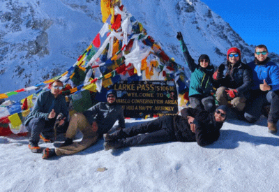
La Larkya Pass resides at an elevation of 5160m. It’s the highest altitude throughout your whole trek. For the acclimatization day, you can explore around the La Larkya Pass then descend to the Bhimthang(3590m) and stay overnight at the guest house. Trek down to Tilije village (2300m) to the high pasture from the rocky terrain of the Himalaya region and pass through Marsyandi river, Mani walls, and forest to the Tal(1700m) and rest overnight. you cross Marsyandi river and Jagat to reach Syange (1200m) and the next day you can take a drive to Beshisahar and then to Kathmandu. For your final day, you can choose your own destination onwards.
Trekkers can organize their expedition with the use of the Manaslu Tsum valley trek map. The maximum altitude, duration, length of the walk, and other information will be provided in detail for travelers. Additionally, the map offers side data that is quite beneficial for organizing this trek, such as the arrival point, goal point, and others.
Description
Manaslu trek map
- Kathmandu to Sotikhola
The Manaslu Tsum Valley Trek begins with a journey from Kathmandu to Sotikhola. Additionally, the journey also travels through the hilly region's beautiful and varied scenery. The area is home to several rice fields, hills that are terrace-planted, and tranquil waterfalls.
This journey's turning point is the market in Arkhet. Along the walk, the stunning Arkhet Khola can be seen, with its various resorts. Jeeps and neighborhood buses are only a couple of the options for getting to this location. Soti Khola is a lovely community surrounded by vegetation. Additionally, it serves as the beginning of the Manaslu Tsum Valley trip.
- Sotikhola to Machha Khola
The Budhi Gandaki basin serves as the trail's starting point for its difficult ascent to Macha Khola. Before reaching Liding, you may enjoy a number of tranquil waterfalls and other natural treasures. Lapubesi village, which is beside a green hill, is a lovely settlement with a campground.
The tranquil and beautiful village will provide you with a very amazing trip. Once you reach Machha Khola, you will have to navigate slippery terrain and nerve-wracking suspension bridges. The village, which is situated on a hillside, has a variety of lodging options and medical amenities.
- Jagat to Lokpa
The Budhi Gandaki River is followed along the trek from Jagat to Lokpa as it winds across arid terrain. While traveling to Lokpa, you will pass through a number of beautiful landscapes. Along the trek, you'll be mesmerized by the entrancing vistas of the snow-capped mountains, notably Shringi Himal (7161m). You will finally reach Lokpa, a small Gurung community with several maize and millet fields, after a few hours of hiking.
- Lokpa To Chumling
The trail from Lokpa to Chumling begins with a difficult climb up to the Budhi Gandaki River. It then goes through Lokpa Waterfall, a stunning, calm waterfall. Small streams like Siyar Khola will be crossed by travelers as they experience breathtaking sights of snow-capped mountains including Ganesh Himal and Shringi Himal (7161m).
- Chumling to Chokkhang paro
Siyar Khola is crossed on the route from Chumling to Chokkhang Paro. A Tibetan-Buddhist community named Chokkhang Paro is home to a number of monasteries, including Rainjam, Gho, and Tanju. Chhokang Paro has a Dzong as well. From the village's perspective, the Ganesh Himal range and Tibetan Himalayan range seem magnificent.
- Chhokang Paro- Nile
The Milarepa Cave, a revered meditation cave devoted to Yogi Milarepa, is located within the beautiful community of Choking Paro. Before eventually rising to Siyar Khola to reach the Nile, you may also visit the lovely Chi Phu Gompa. You can cross the river and go to Gongye Gompa at the same time. You may continue on from the Nile to Mu Gompa, which is close to the Tibetan border.
- Nile to Chumling.
Nile is the settlement near Mu Gompa. you return to Chumling to give continuity to your trek.
- Chumling to Bi phedi
As we continue on our adventure, descending toward lower Tsum valley, Bi Phedi is the next stage of this trek. Before reaching Lokpa, you will next pass through a number of Rachen communities. To access the Manaslu Circuit Trail across the Budhi Gandaki River, you will have to cross a suspension bridge. You may get to Bi Phedi by following the river past the towns of Nyak, Deng, and Rana.
- Bhi Phedi to Namroung
The route from Bihi to Namrung travels through a number of villages in a barren landscape. Following that, the trail ascends through a lush, alpine woodland. Before you reach Namrung, a tranquil waterfall and Buddhist monastery in Ghap would charm any traveler. The Nam Gumba is a stunning feature located along a route near Namrung. Ngadi Chuli (7871m), Boudha Himal (6672m), Himal Chuli (7893m), and other mountains can be seen from this viewpoint.
- Namroung to Samagaon
The footpath from Namrung to Sama Gaon winds along the Budhi Gandaki River over a mountain. The Lama and Sho villages along the way provide breathtaking views of the snow-covered mountains. When you go to Lho, you may check out Ribung Gompa. We will arrive at Shyala after a challenging ascent over a smooth and comfortable path. After arriving in Sama Gaon, we will tour the neighborhood and the renowned Pema Chyoling Lhakhang Monastery.
- Samagaon to Samdo
Incredible views of snow-capped mountains, including Manaslu, may be seen along the path from Sama Gaon to Samdo (8163m). As we softly rise to Samdo along a peaceful track, the climbing road leads you to the ice lake Birendra Tal. You may reach Samdo's Taka Choling Gompa as you cross breathtaking Mani walls.
- Samdo to Dharmasala
From Samdo to Dharamsala, a lovely walk leads past lovely streams till it reaches Larkya Bazaar. Before arriving at the base of Larkya La, the steep route then crosses past Mani walls (5160m). Then, a trail gradually ascends Larkya Bazaar and takes you to Larke Phedi.
- Trek down to Bhimthang -Larkya la pass
Before reaching Larkya La, the path from Dharamsala to Bimthang travels through the Larkya Glacier (5160m). From these mountain passes, the Manaslu and Annapurna massifs appear to be very gorgeous. To get to Bimthang, the walk descends along an icy slope that offers magnificent views of the glacier.
- Bhimthang to Dharapani
You may reach the Gho by taking the path from Bimthang to Dharapani, which passes through lovely villages and alpine woods. You will travel through Tilje and other tiny towns as you continue your trek. From Tilje to Dharapani, the route declines. You will cross Dudh Khola again on the suspension bridge before reaching this lovely town.
- Dharapani to Beshisahar
Starting off-road, the trail travels to Besisahar from Dharapani. To go to Besisahar, you may use a jeep, which would take you around four hours. To get to Syange village, you must descend a route. Before ultimately descending to Besisahar, this path continues to ascend to Gharmu Phant.
- Beshisahar To Kathmandu
The travel from Besisahar to Kathmandu is a brief, beautiful one that takes around 6-7 hours. All visitors will be charmed by the beautiful surroundings, which feature other rivers and beautiful green hills. This beautiful journey goes past Dumre, where you may take another route to Pokhara.

